In 2021 we asked for your feedback on:
- what you love about Alfrieda Street
- what you think future Alfrieda Street should look like.
We used your feedback to create a vision for Alfrieda Street and prepare the draft Alfrieda Street Public Realm Masterplan.
Feedback
Now we want to know what you think of this draft. We want you to read our recommendations and give your feedback.
Sections
The Masterplan includes all Alfrieda Street from Main Road East to Taylors Road. It focuses on 3 areas:
- Civic Walk
- Nature Walk
- Neighbourhood Walk.

Civic walk
Civic Walk options
The Plan presents two options for the Civic Walk section. We have created 2 options with consideration for the fair allocation of space.
The difference between the 2 options is the positioning of the public realm.
- Option 1 has the public realm on the west
- Option 2 has the majority of the public realm on the east.
Click on the flashing icons for more information.
Option 1

Option 2

See how the options compare
| Masterplan objectives | Option 1 | Option 2 |
|---|---|---|
| Provide a safe, welcoming public space that supports day and night-time dining culture | Large areas of continuous public realm and space for community gathering and events | 2 separate areas of public realm for community gathering and events separated by road crossings |
| Increase space for on-street trading | No changes to existing footpath trading areas. More space would be provided | There would need to be some removal of footpath trading outside #53 Alfrieda Street to allow room for the relocated bus stop |
| Increase space for events and activities | Continuous public realm that could support large events without the need for the closure of Alfrieda Street. A large space provided in front of the library | There are a number of crossing points to negotiate that will reduce the smooth flow of traffic and potentially create conflict |
| Reduce traffic congestion | Minimal conflict points between buses and other vehicles as there are minimal crossing points to negotiate | Multiple crossing points reduce the smooth flow of traffic and create conflict points |
| Improve connectivity to public transport, surrounding streets and activity nodes such as St Albans Community Centre | Good connection to library, St Albans Community Centre and the Alfrieda Street Plaza | The connection to the library requires crossing over Alfrieda Street, the new plaza would require modification |
| Prioritise active transport (walking and cycling) over through traffic | Wide footpaths and separated bike lane | Cyclists and pedestrians have to share the footpath on the southern end and there are conflicts at the crossing points |
| Prioritise movement of public transport | Buses travel in one straight line | Buses have to negotiate a number of pedestrian crossings |
| Increase tree canopy cover and greening | All healthy mature trees will be retained as well as new trees maximising shade, canopy cover and cooling | 16 healthy mature trees would be removed and new trees would not shade the road surface reducing cooling |
| Relocate on-street car parks along Alfrieda Street and Collins Street with no net loss of car park | Zero net loss of car park | Net loss of 8 car parks |
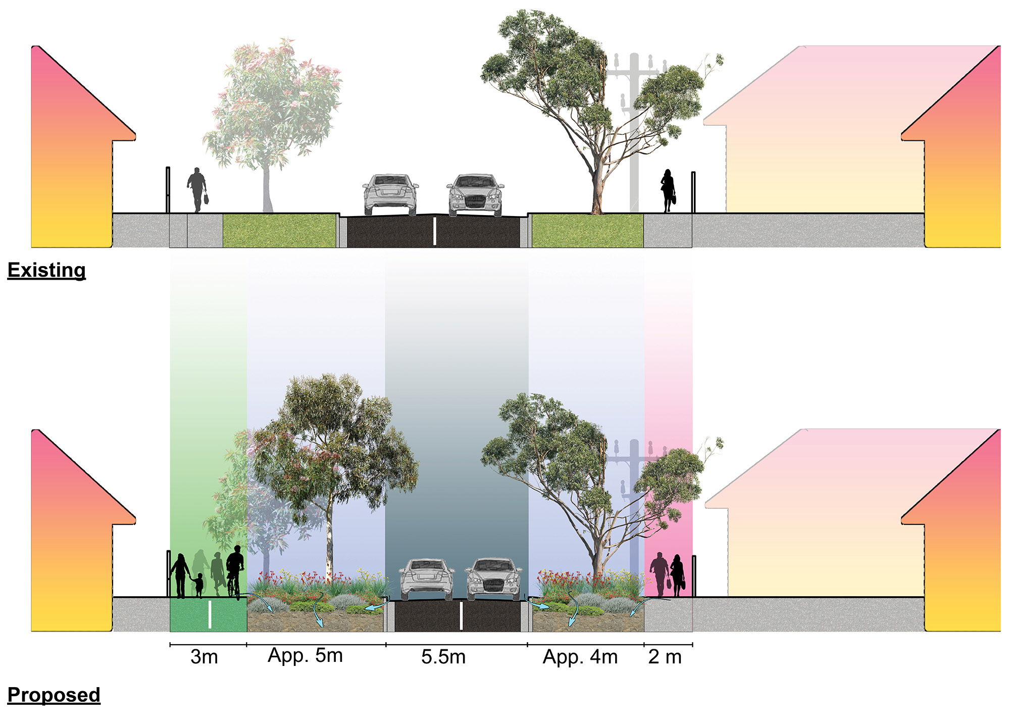
Proposed street design
This street cross section shows the existing and the 2 proposed street designs including heat analysis for the Civic Walk.

Nature walk
Click on the flashing icons for more information.

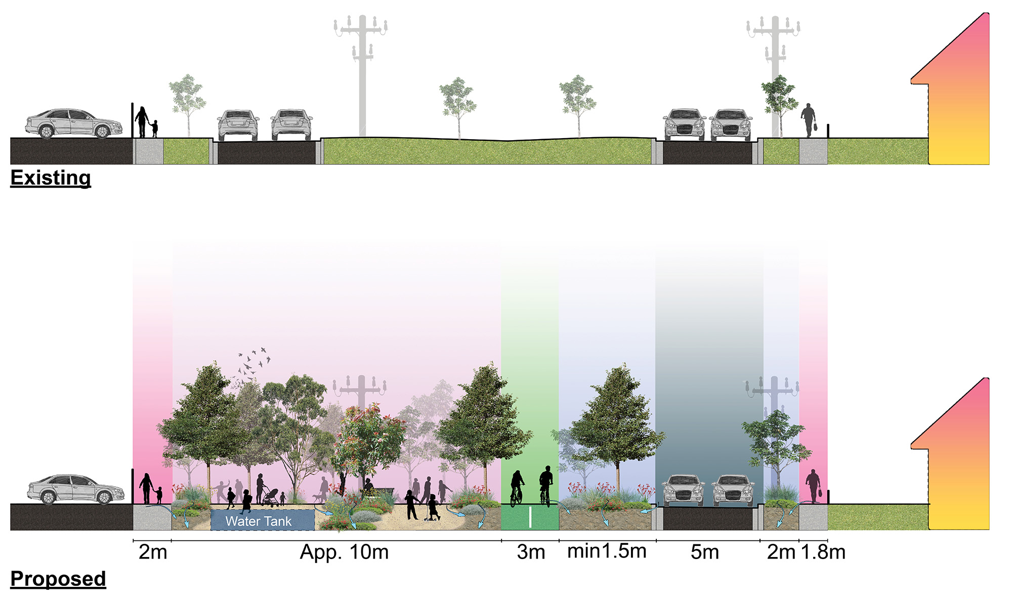
Proposed street design
This cross section shows the existing and proposed street design for the Nature Walk.
Neighbourhood walk
Objectives
- provide safe, inviting, and accessible neighbourhood that encourages walking and cycling
- provide safe and easy connection to shops, community hubs and green spaces
- increase shade tree canopy and enhance urban biodiversity.
Click on the flashing icons for more information.

Proposed street design
This cross section shows the existing and proposed street design for the Neighbourhood Walk.